

La Niña back this summer? Not likely – and unofficial declarations are jumping the gun
- Written by: Andrew King, Senior Lecturer in Climate Science, ARC Centre of Excellence for 21st Century Weather, The University of Melbourne
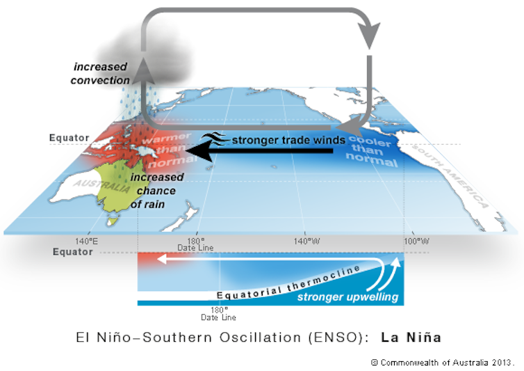
It’s the height of summer and many Australians have already experienced heatwaves, heavy rains and even significant bushfires over the Christmas and New Year period. But could we be in for something different as summer draws to a close?
Lower sea surface water temperatures in the central Pacific Ocean are leading to speculation about a La Niña event starting to form, raising the risk of wet weather. That would be unusual because La Niña events typically start in winter and get going properly in spring, before “decaying” in late summer and autumn.
Given the time of year, it would be hard for a proper La Niña event to get going now. But the Bureau of Meteorology’s outlook does point to a probable wet end to summer over most areas of Australia.
As the climate continues to change, there are challenges in monitoring and predicting El Niño and La Niña events. The best source of information is the Bureau’s outlooks as they encapsulate lots of climate information and don’t just focus on one driver of Australia’s climate.
What is a La Niña event and are we heading into one?
La Niña events are characterised by below-average temperatures in the central and eastern tropical Pacific Ocean and warmer waters in the west nearer to Australia. They often, but not always, bring wetter conditions for eastern and northern Australia. In contrast El Niño events, which are at the opposite end of the El Niño-Southern Oscillation (ENSO), usually bring drier weather to most of the continent.

If a La Niña is on the horizon, many of us – especially people working in agriculture, emergency management and water resources – are keen to know in advance.
Since early last year, there has been speculation about a La Niña forming. The metrics used to determine if we are in an El Niño or La Niña (or somewhere in between) have been close – but not quite at the La Niña threshold – for much of the time over the past few months.
At the moment, some of the indicators used to track the state of the Pacific are just breaching the thresholds used for a La Niña event. This has led to discussion in some media outlets that we’re heading into a “rare summer La Niña”.
It’s worth noting that a criterion for a La Niña event is sustained cooler-than-normal conditions in the central Pacific, because there is some week-to-week fluctuation in sea surface temperatures. We are not yet close to having the three months of below average temperatures in the central Pacific that would often be required to declare a La Niña event.
 The Niño-3.4 index represents central Pacific sea surface temperatures. It has just crossed the La Niña threshold but would need to stay there for a La Niña to be declared.
Bureau of Meteorology, CC BY
The Niño-3.4 index represents central Pacific sea surface temperatures. It has just crossed the La Niña threshold but would need to stay there for a La Niña to be declared.
Bureau of Meteorology, CC BY
In autumn, the variability in tropical Pacific Ocean temperatures starts to settle down, so it would be very hard for a La Niña to start in January and be maintained through to April. Indeed, we often see blips of warmer or cooler conditions at this time of year.
The Bureau of Meteorology has not declared a La Niña and instead notes that the El Niño-Southern Oscillation (ENSO) is currently “neutral”“ (neither El Niño nor La Niña), albeit with some indices drifting close to La Niña thresholds. Any unofficial declaration of a La Niña is jumping the gun.
Tracking drivers of climate variability in a warming world
Keeping track of how the drivers of Australia’s climate are evolving is tricky. Climate change makes it even more complicated.
The rapid warming of our oceans means the characteristics of La Niña events may well be changing. Just identifying if we are in a La Niña is trickier than it used to be, so new measures to keep track of ENSO may become more useful.
Also, by warming the planet through our greenhouse gas emissions, we may be changing other aspects of La Niña events and their effects on Australian weather and climate.
At the moment, it’s hard to see any such changes because we don’t have lots of real-world La Niña events to study and detect trends. However, some studies suggest we should expect more strong La Niña events and stronger rainfall responses as we keep warming the planet.
Australia’s complex climate
La Niña is just one of many factors that can affect Australia’s weather.
Ocean temperature and wind patterns in the Indian Ocean, Southern Ocean and tropics all combine to influence our day-to-day weather. While La Niña events are often wetter on average, cooler waters in the Eastern Pacific do not guarantee rainfall and floods.
Our recent study of the unusually wet 2022 in Eastern Australia (the most recent La Niña period), found La Niña can help promote the background conditions needed for heavy rainfall, such as more onshore winds over Eastern Australia.
But it is the chaotic, and sometimes unlucky, behaviour of the day-to-day weather systems such as tropical cyclones, highs, lows and cold fronts that ultimately bring the extreme weather. Therefore, it is foolish to look at climate drivers such as La Niña in isolation to forecast the weather and climate.
This is why the Bureau is moving away from forecasts that focus on individual climate drivers like La Niña and are instead emphasising their long-range forecast, which takes into account all the drivers of Australia’s weather.
This shift in communication of climate information is partly due to an effort to end sensationalist reporting on El Niño and La Niña that can lead to public misunderstanding.
 The next few months are more likely to be wet than dry for most of Australia.
Bureau of Meteorology, CC BY
The next few months are more likely to be wet than dry for most of Australia.
Bureau of Meteorology, CC BY
Unfortunately, a reduction in information on El Niño and La Niña from the Bureau risks a vacuum that may be filled with unofficial climate statements.
The Bureau’s long-range forecasts are the best source of information for Australians wishing to know what weather and climate conditions the next few months may bring.
Authors: Andrew King, Senior Lecturer in Climate Science, ARC Centre of Excellence for 21st Century Weather, The University of Melbourne


 Daily Bulletin


